
legislation
NOAA’s streamlined GeoXO program could cost $6.6 billion less than originally projected, but fewer satellites, removed instruments, and incomplete backup plans create new questions about future weather coverage.
What to Know
- NOAA reduced its planned GeoXO constellation from six satellites to four.
- Projected lifecycle cost declined from $19.6 billion to $13 billion, although GAO says the revised estimate still needs independent validation.
- Three planned instruments for lightning, coastal waters, and atmospheric composition were removed.
- A timing mismatch could leave NOAA without an operational spare satellite for several months around 2032.
- GAO did not conclude that current weather forecasts have already deteriorated.
Weather satellites operate far from everyday life, but their observations influence hurricane warnings, aviation routes, wildfire monitoring, flood preparation, and decisions made by emergency managers. NOAA’s Geostationary Extended Observations program, known as GeoXO, is intended to replace today’s geostationary satellites as they approach the end of their service lives.
Commerce officials restructured GeoXO to reduce its projected cost and narrow its scope. A Government Accountability Office review found that the revised design may still preserve major imaging and atmospheric-sounding capabilities. Removed instruments and incomplete contingency planning, however, create a budget-versus-capability question that policymakers must resolve before the first scheduled launch in 2032.
What NOAA Cut and What It Kept
NOAA originally planned six GeoXO satellites operating across East, West, and Central orbital positions. Five instrument types would have provided imagery, atmospheric profiles, lightning detection, air-quality measurements, and coastal-water observations.
Commerce directed the program to reduce lifecycle costs in 2025. Its approved April 2026 baseline removed both Central satellites and retained two East and two West spacecraft.
|
Program element |
Original baseline |
April 2026 baseline |
|
Satellites |
6 |
4 |
|
Orbital positions |
East, West, and Central |
East and West |
|
Instrument types |
5 |
2 |
|
Projected lifecycle cost |
$19.6 billion |
$13 billion |
|
First planned launch |
2032 |
2032 |
Remaining satellites would carry visible and infrared imagers and hyperspectral infrared sounders. NOAA plans to place sounders on all four spacecraft, rather than limiting them to the former Central position. First-generation GeoXO hardware would initially use a legacy Advanced Baseline Imager, with the upgraded imager planned for later satellites.
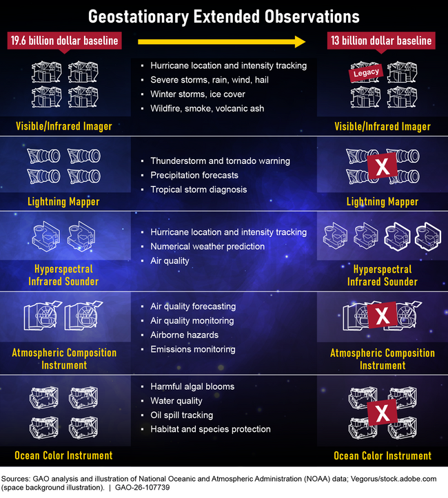
GeoXO’s revised design retains imaging and atmospheric sounding while removing three planned instrument types, via U.S. Government Accountability Office.
Projected savings amount to $6.6 billion relative to the original baseline. That difference remains an estimate rather than verified savings because GeoXO had not completed an independent cost assessment for the revised program when GAO finished its review.
Cost uncertainty matters, but the public consequences depend on which observations the narrower system no longer provides.
Which Observations Could Be Affected?
Three removed instruments served different public functions.
A next-generation lightning mapper was intended to track lightning within storm cells, support severe-weather warnings, and help aircraft avoid lightning hazards. Current GOES satellites already provide space-based lightning mapping, so eliminating the planned replacement could eventually interrupt that capability unless NOAA secures another source.
An Ocean Color instrument would have monitored harmful algal blooms, water quality, sediment, ecosystem changes, and oil spills. Coastal communities, fisheries, water managers, and public-health agencies could have used those frequently updated observations.
An Atmospheric Composition instrument would have measured pollutants such as ozone and nitrogen dioxide. Hourly observations were intended to support air-quality forecasts and track smoke, emissions, and airborne hazards across North America.
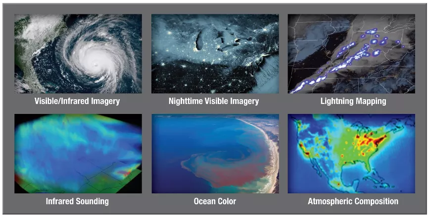
NOAA’s original GeoXO design combined weather imagery with lightning, ocean-color, atmospheric-composition, and sounding observations, via NOAA National Environmental Satellite, Data, and Information Service.
GeoXO will still retain important capabilities. Visible and infrared imagers would monitor clouds, hurricanes, fires, smoke, fog, volcanic ash, and other hazards. Hyperspectral sounders would measure atmospheric temperature and moisture more frequently than current polar-orbiting sounders, potentially improving short-range forecasts.
A narrower instrument package therefore does not mean an absence of satellite weather information. It means future users may receive fewer kinds of environmental observations than NOAA originally planned.
Capability decisions also intersect with a separate question: whether working satellites and backups will be available when needed.
Why the Spare-Satellite Timeline Matters
NOAA policy calls for two operational geostationary satellites and one operational spare. East and West satellites provide continuous coverage, while a spare can replace one that fails or becomes impaired.
Current spare satellite GOES-16 is projected to reach the end of its service life in October 2032. GeoXO-1 is also scheduled to launch in 2032, but several months of testing would follow before it became operational in early 2033.
That schedule could produce a period without an operational spare. East and West observations would continue if both working satellites remained healthy. A data gap would arise only if one became impaired while no replacement was ready.
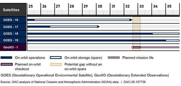
Current schedules could leave NOAA without an operational geostationary spare for several months between late 2032 and early 2033, via U.S. Government Accountability Office.
GAO found that NOAA’s contingency policy met many leading practices, but it lacked a complete analysis of failure impacts and detailed procedures for deploying every backup option. Potential alternatives include call-up spacecraft and reciprocal arrangements with international partners.
Planning those responses before a failure matters because weather observations cannot be reconstructed after a satellite stops transmitting.
Why Gaps Matter to Transportation and Households
Geostationary satellites hold a fixed view approximately 22,300 miles above Earth. Constant coverage allows forecasters to watch storms develop and move instead of waiting for occasional snapshots.
Aviation operators use satellite data to identify thunderstorms, volcanic ash, fog, smoke, icing conditions, and other hazards that can affect routes and airport operations. Emergency managers rely on rapid imagery to monitor hurricanes, wildfires, floods, and severe storms.
Households experience those systems through warning time, evacuation decisions, insurance risks, flight delays, road conditions, and local emergency alerts. Missing observations would not automatically make every forecast wrong, but they could reduce the information available during fast-changing events.
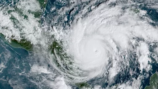
Geostationary satellites continuously monitor hurricanes and other rapidly changing hazards that threaten lives and property, via NOAA National Environmental Satellite, Data, and Information Service.
Benefits also extend beyond dramatic storms. Satellite observations support air-quality notices, smoke tracking, flood assessments, wildfire response, coastal monitoring, agriculture, shipping, and routine forecasts used by businesses and families.
Those uses explain why the policy debate should not treat spacecraft counts as the only measure of performance.
What Policymakers Should Require Next
GAO made three recommendations to the Department of Commerce. One calls for complete documentation supporting the revised cost estimate. Another seeks stronger contingency plans covering failure impacts, call-up spares, and alternative data sources. A third requests comprehensive technology-readiness reports for each remaining instrument.
NOAA agreed with all three recommendations. Each remained open when GAO released its report, meaning GAO had not confirmed full implementation.
Congress and Commerce should be able to compare the projected budget reduction with the capabilities removed, the cost of alternative observations, and the consequences of a delayed launch or on-orbit failure. Reporting should also distinguish between a temporary loss of backup capacity and an actual interruption in operational data.
Future reviews can then test whether the revised program remains on schedule, whether the $13 billion baseline is credible, and whether NOAA has practical replacements for observations no longer carried by GeoXO.
Wrap Up
Reducing GeoXO from six satellites to four lowers its projected cost and preserves major imaging and atmospheric-sounding functions. Savings alone, however, do not show whether the revised system provides the best value.
Removed lightning, ocean-color, and atmospheric-composition instruments narrow the information NOAA originally intended to collect. A possible period without an operational spare adds a different risk tied to schedule and contingency planning.
No evidence in GAO’s review shows that current forecasts have already worsened. Policy choices made now will instead determine what observations, backups, and warning capabilities remain available during the 2030s.